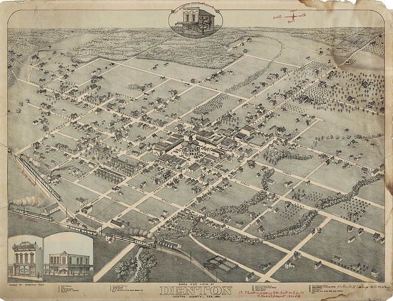
The Birdseye Map of Denton- 1883
by Mike Cochran
After the Civil War, a peculiar sort of mania swept the nation employing the latest technology of perspective map making. Many former army engineers and cartographers made their living by traveling the country and producing by subscription, meticulously detailed artistic renderings of the various communities as they might be seen from the air. Before the days of air travel, these "Bird's Eye" lithographs were quite a popular novelty and were produced in thousands of communities across the land.
One such cartographer, German born Augustus Koch, had served in the Union Army during the Civil War as a clerk and draughtsman in the Engineers Office in St. Louis. Although his English was poor, he was later commissioned as an officer and assigned to one of the Black regiments serving in Mississippi where he drew maps for the advancing Union forces. By 1865 he is thought to have contracted malaria and at 25, was discharged from the army. Little is known about his activities for several years but by 1868 he appears to have settled into the profession of itinerant Bird's Eye cartographer employing those skills acquired during his military service. His first signed Bird's Eye lithographs date from 1868 when he published maps of Cedar Falls, Vinton, and Waterloo, Iowa. At that point his career seemed to take off and in rapid succession, maps by Koch were produced in every section of the country. In 1870 he produced 5 maps in Utah, Wyoming and California.
In 1873 Koch produced the first of his Texas work by etching maps for Austin, San Antonio and Brenham. On a return trip to Texas in 1883, Koch produced the Bird's Eye Map of Denton. Little is known about the circumstances of the publication of this map but some things may be inferred from other sources. We know that Koch published the map himself and that underwriters received special mention in the display. The banks of the town were all shown in greater detail, evidence of their financial participation in the project.
As to the accuracy of the map, Koch was well regarded for his faithful representations. Writing of his work in Lincoln, Nebraska, one writer says of Koch, "Mr. Koch has with him his sketch which shows every street, block, railroad track, switch and turn-table, every bridge, tree and barn, and in fact every object that would strike the eye of a man up a little ways in a balloon from a point a little northwest of the B. & M. depot. The architectural style, dimensions, and position of each building is faithfully preserved in the sketch..." An engineering map of Denton from 1882 that shows the positions of the streets and buildings of the town, corroborates Koch's vision and was no doubt used as a source for bird's eye map. There are few structures still standing that are on the old map but they include the Union Pacific Freight Depot, on East Hickory, the Scripture Building and the May-Wilkirson-Cochran (1878) house at 609 W. Oak St. One interesting discrepancy in the map in it's depiction of the old Robert E. Lee School which was on the site of the First United Methodist Church. When Koch was producing his map, the school was not yet completed and Koch had to use his imagination to finish it out. Although similar, Koch's version is not at all what was built.
In all, Koch produced more that 112 Bird's Eye maps across the country and 21 in the state of Texas. His career spanned 30 years and his last known map was produced in Montana in 1898. We are fortunate to have this excellent example of the cartographic arts of our town for with it we are afforded a window on the past that gives a real feeling for the Denton of the 1880's. The only known example of the original Koch map of Denton is in the Emily Fowler Public Library. The Historical Society of Denton County has produced a reprint of this rare map and it is available to the public at the Courthouse on the Square Museum.
Note: The original Birdseye Map of Denton is in the Denton County Public Library. This scan courtesy of the Amon Carter Museum, Ft. Worth, Texas.